 India
India
 World
World
 Entertainment
 Sports
 Chhattisgarh
 Haryana
 Delhi
Delhi
 Religious
 Business
 Tech & Auto
 Education
 Health
 Andhra Pradesh
 Telangana
 Sikkim
 Odisha
 Jharkhand
 Assam
Assam
 Nagaland
Torrential rain in some areas, 40-degree heat in others
Find out what the weather will be like in your state; IMD issues latest update
New Delhi, The Southwest Monsoon is steadily gaining momentum across the country, with its activity intensifying in most states. While torrential rains, strong winds, and thunderstorms continue in many regions, heat and humidity are still troubling people in other parts. According to the latest forecast by the India Meteorological Department (IMD), varied weather conditions are expected across different states on June 25.
By June 24, the monsoon had reached parts of Gujarat, Madhya Pradesh, Maharashtra, Chhattisgarh, and Jharkhand, raising the likelihood of widespread rainfall in the coming days. Here is the latest state-wise weather update:
Active monsoon in East India; heavy rain alert
The monsoon remains fully active across West Bengal, Odisha, Jharkhand, and Bihar. Moderate to heavy rainfall, accompanied by thunderstorms and gusty winds reaching speeds of 40–50 kmph, is expected in several locations across these states. Very heavy rainfall is also predicted for parts of northern Odisha and Bihar.
Mixed weather conditions in North India: clouds and heat
Partly cloudy skies are expected over Delhi, Punjab, Haryana, and western Uttar Pradesh. In the national capital, Delhi, the maximum temperature is likely to hover between 38°C and 40°C. However, light rain and thunderstorms may offer some relief from the heat. Meanwhile, light to moderate rainfall is forecast for the mountainous regions of Himachal Pradesh and Uttarakhand.
Weather likely to change in Delhi-NCR from June 26
According to the IMD, the maximum temperature in Delhi-NCR is unlikely to exceed 40°C this week. Intermittent light rain, strong winds, and thunderstorms will help provide relief from the heat and humidity.
On June 25, the maximum temperature is expected to be 39°C, and the minimum temperature is likely to be 28°C. The sky will remain partly cloudy, and no specific weather warnings have been issued.
However, a further change in the weather is expected on June 26. The department has forecast rain accompanied by thunderstorms for that day, with the maximum temperature expected to reach 40°C and the minimum to hover around 28°C.
Dual impact of rain and hot winds in Western India
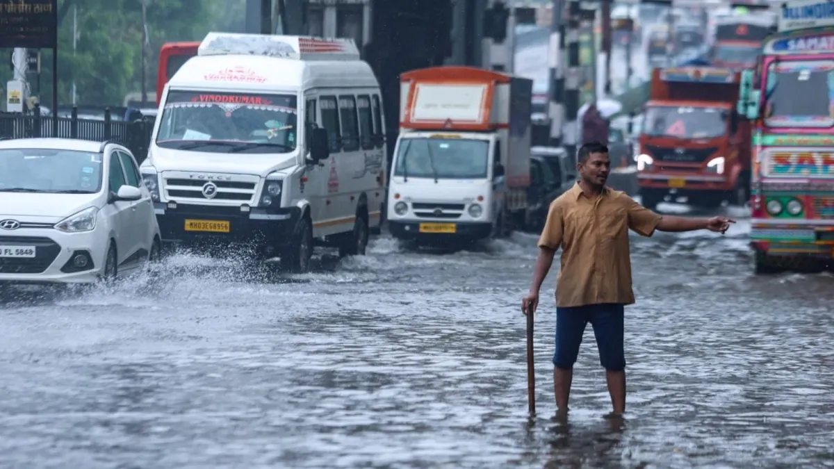
The monsoon is advancing rapidly across Rajasthan and Gujarat. Heavy rainfall is predicted for South Gujarat and coastal Maharashtra, while the threat of hot winds and dust storms persists in Western Rajasthan. Torrential rains are likely to continue in Mumbai and surrounding areas.
Monsoon fully active in South India
The monsoon is progressing well across Kerala, Karnataka, Telangana, and Tamil Nadu. Thunderstorms, lightning, and heavy to extremely heavy rainfall are expected in several areas of Kerala and coastal Karnataka. Meanwhile, despite scattered showers, heat and humidity will persist in Hyderabad and Bengaluru.
Risk of waterlogging due to heavy rain in Central India
Heavy rainfall and thunderstorm activity are likely to continue across Madhya Pradesh, Chhattisgarh, and the Vidarbha region of Maharashtra. There is a risk of waterlogging in some areas due to extremely heavy rainfall. However, a slight drop in temperature may be recorded due to the continuous rain.
Rain continues in Northeastern states
A spell of heavy to very heavy rainfall is ongoing across most Northeastern states, including Assam, Meghalaya, and Nagaland. Additionally, a heavy rainfall alert has been issued for Sikkim and sub-Himalayan West Bengal up to June 25.
Need for caution; advice for farmers and travelers
While the monsoon is compensating for the earlier rainfall deficit across most parts of the country, caution is advised regarding localized heavy downpours. Farmers are urged to pay special attention to crop management, while travelers should check weather updates and IMD alerts before setting out. It is essential to exercise extra caution in areas experiencing heavy rainfall, given the risk of floods and landslides.